Going after the Egg - The July 3rd Attempt
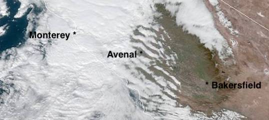
Sunday morning July 3rd started hot at Avenal. A projected high of 104 seemed realistic as the early sun beat down on the hangar as I did some maintenance on the tractor.
Forecasts had held overnight and we were looking at good conditions from New Cuyama on and 16k in the Owens Valley. This could happen.
Matt showed up around 10:30 and we discussed our options. It looked like we'd need 100+ temps on the ground to get to 6-7k near Shandon. We'd planned on launching around noon, but temps were a bit slow in coming on.

We finalized preparations in the glider. More backup GPS, cameras, video gear, stereo speakers (yes, stereo speakers), batteries, clothes, lots more water. My concern was sinking out somewhere in the CA Valley and having a 3-4 hour wait in 105 heat, so we had lots of water on board.
Just before 1:00 we were off the ground. A little bit of a breeze helped the club 150/150 lug our heavy bird into the air. The air was well textured as we climbed through 4k heading SW behind the towplane. Our intention was a high tow towards Shandon to get us out of the Avenal valley and over into the higher temps forecasted near Shandon. At about 6500 north of Shandon we hit a decent thermal and pinned off. It turned out to be a mystery bump, but we had good position to dive south into the air that was supposed to be working.
Nearing Camatta, we hadn't hit anything but pretty much smooth air. Finally a few miles South of Camatta we hit a little bump that I was able to work to 6500. Game On! Driving into the La Panza range, the lift was there, though not super consistent but working to 7k+. We worked slowly along for the first 20 miles or so. Just making sure we were getting a sense of the day before dropping the nose and racing.
As we approached the Cuyama Valley near Branch Mountain, the first Cu popped down near McPherson Peak. I thought Matt was going to punch the canopy as he raised his hands in the air with a "YES!" An exclamation that the models were working and that we were on the right path.
The convergence was working and we picked up the pace a bit, climbing higher with each successive thermal down the Cuyama Valley. Over Dead Mans Canyon we climbed through 10k and had nice markers popping along the convergence towards McPherson and on towards Santa Barbara Canyon. The only issue was that they weren't at 13k and there weren't any cu towards Mt. Pinos or Tehachapi.
On the radio, we could hear the Tehachapi pilots working ragged lift at 8-9k. Bummer, the model had fallen apart after such a great start. We pressed on.
Gliding in towards Mt. Pinos, we'd left our last cloud near Santa Barbara Canyon. Mt. Pinos loomed awfully high on the canopy. Approaching from the west we were seeing south winds picking up and no good signs for the next 50 miles. Even the high cu in the distance lacked the appearance of being ground based.
We worked the spine up into Pinos from the west in a little ridge and thermal lift. A few turns in ratty lift got us over the peak.
We passed directly over the top of the hill, swooping across the trees about 200ft off the deck at most. We passed over a parking lot for hikers, I hope someone looked up at the right time as our graceful bird swooped into the Valley.
Matt worked a bubble on the SE side of the mountain that just wouldn't break loose. We didn't have glide over the top of Frasier, but that was where I wanted to go. I knew we had easy glide to Quail Lake and we knew that if we bailed over the back to the Valley, we'd probably be landing at El Tejon duster strip. The San Joaquin Valley is not where you want to be. I took over and worked out a spine to the south eventually finding a climb that would get us over Frasier. Frasier didn't offer much, but at least we could see Quail Lake and knew what our options were. We took the route deeper into the Tehachapi's and after crossing I5 connected with what felt like a bit of wave. We stopped and I worked the weak lift for a bit more altitude. That gave us a reasonable glide to Rosamond, probably even could sneak into Tehachapi if needed, so we kept going. Matt worked us bit by bit to Tehachapi bumping us higher with each successive climb in the SE winds. At the very least we knew we could get a tow from Tehachapi or Cal City the following day and see if we could make it back to Avenal.
Over the windmills he climbed us up through 10k again and then as we headed to Cache Peak I took over. At Cache Peak we climbed through 11k before I headed towards Walker Pass and Inyokern. We'd got confirmation from Dan and Walt out of Tehachapi that there were tows available in Inyokern and in Bishop, so we pressed on. Gliders were starting to come out of the Sierra now on their way home to Tehachapi. Matt climbed us through 14k at Walker Pass and Owens Peak so further we went.
I got a climb near Olancha peak that gave us the room to get in behind Horseshoe Meadows to a nice looking cloud. A bit of pucker factor as we drove deep into the Sierra and were rewarded with a smooth 8 knot thermal to 16k.
That gave us a final glide to Bishop if things went well. We zoomed past Mt. Whitney at 100knots and skirted some virga from the OD near Kings Canyon. Through the virga, the bottom started to fall out and our 4k over glide to Bishop disappeared quickly. Thankfully a valley thermal was there and put us well above glide again after a few turns in the southerly valley winds.
We crossed over into the Whites and found trashy air to the northwest of Black Mountain. Matt struggled in each of the bowls he knows from his early days in hang gliders in the Owens. It was a nostalgic flight for me as well. Noting some of the bowls and ridges I'd saved flights on in my hang glider. As it was now after 7:00pm it was clear that we weren't going to make it to Air Sailing to capture the egg. We had about 200 miles to go and 1:16 of daylight left. We were close, but not close enough.
We headed into the valley to get away from the choppy air and found smooth lift over the Owens river that drifted slowly towards the Glass Mountains. We just turned lazy circles and enjoyed the moment and beauty of the Owens Valley for the next 45 minutes. We pushed northwest towards the glass mountains and then raced back to get down before official sunset.
On landing, John and Karl came out to help us push back to the tie-down area. A band was playing in the hangar, blasting Seven Bridges Road for us as we pushed 5H into position. Awesome!
We tied down the glider, took pictures of the blazing evening sky and marveled at what we'd just accomplished. No we hadn't captured the egg, but we'd proven to ourselves that it was possible. We were a few hours too late, but only a few hours an on a day that didn't work out as forecasted.

Air Sailing, watch out, the Central California crew has an eye on the prize.
Next -- Getting home or not
Forecasts had held overnight and we were looking at good conditions from New Cuyama on and 16k in the Owens Valley. This could happen.
Matt showed up around 10:30 and we discussed our options. It looked like we'd need 100+ temps on the ground to get to 6-7k near Shandon. We'd planned on launching around noon, but temps were a bit slow in coming on.
We finalized preparations in the glider. More backup GPS, cameras, video gear, stereo speakers (yes, stereo speakers), batteries, clothes, lots more water. My concern was sinking out somewhere in the CA Valley and having a 3-4 hour wait in 105 heat, so we had lots of water on board.
Just before 1:00 we were off the ground. A little bit of a breeze helped the club 150/150 lug our heavy bird into the air. The air was well textured as we climbed through 4k heading SW behind the towplane. Our intention was a high tow towards Shandon to get us out of the Avenal valley and over into the higher temps forecasted near Shandon. At about 6500 north of Shandon we hit a decent thermal and pinned off. It turned out to be a mystery bump, but we had good position to dive south into the air that was supposed to be working.
Nearing Camatta, we hadn't hit anything but pretty much smooth air. Finally a few miles South of Camatta we hit a little bump that I was able to work to 6500. Game On! Driving into the La Panza range, the lift was there, though not super consistent but working to 7k+. We worked slowly along for the first 20 miles or so. Just making sure we were getting a sense of the day before dropping the nose and racing.
As we approached the Cuyama Valley near Branch Mountain, the first Cu popped down near McPherson Peak. I thought Matt was going to punch the canopy as he raised his hands in the air with a "YES!" An exclamation that the models were working and that we were on the right path.
 |
| Climbing through 10k over Dead Man's Canyon. |
On the radio, we could hear the Tehachapi pilots working ragged lift at 8-9k. Bummer, the model had fallen apart after such a great start. We pressed on.
 |
| Crossing the Cuyama River near Santa Barbara Canyon |
Gliding in towards Mt. Pinos, we'd left our last cloud near Santa Barbara Canyon. Mt. Pinos loomed awfully high on the canopy. Approaching from the west we were seeing south winds picking up and no good signs for the next 50 miles. Even the high cu in the distance lacked the appearance of being ground based.
 |
| Approaching Mt. Pinos |
We passed directly over the top of the hill, swooping across the trees about 200ft off the deck at most. We passed over a parking lot for hikers, I hope someone looked up at the right time as our graceful bird swooped into the Valley.
 |
| Slipping over the top of Mt. Pinos. Hmm, this isn't 13k at cloudbase. |
Matt worked a bubble on the SE side of the mountain that just wouldn't break loose. We didn't have glide over the top of Frasier, but that was where I wanted to go. I knew we had easy glide to Quail Lake and we knew that if we bailed over the back to the Valley, we'd probably be landing at El Tejon duster strip. The San Joaquin Valley is not where you want to be. I took over and worked out a spine to the south eventually finding a climb that would get us over Frasier. Frasier didn't offer much, but at least we could see Quail Lake and knew what our options were. We took the route deeper into the Tehachapi's and after crossing I5 connected with what felt like a bit of wave. We stopped and I worked the weak lift for a bit more altitude. That gave us a reasonable glide to Rosamond, probably even could sneak into Tehachapi if needed, so we kept going. Matt worked us bit by bit to Tehachapi bumping us higher with each successive climb in the SE winds. At the very least we knew we could get a tow from Tehachapi or Cal City the following day and see if we could make it back to Avenal.
Over the windmills he climbed us up through 10k again and then as we headed to Cache Peak I took over. At Cache Peak we climbed through 11k before I headed towards Walker Pass and Inyokern. We'd got confirmation from Dan and Walt out of Tehachapi that there were tows available in Inyokern and in Bishop, so we pressed on. Gliders were starting to come out of the Sierra now on their way home to Tehachapi. Matt climbed us through 14k at Walker Pass and Owens Peak so further we went.
 |
| Climbing back behind Horseshoe Meadows. |
 |
| Looking NW towards Whitney and Kings Canyon |
 |
| Mt Whitney, hopefully no hikers still on top as it was after 6:00pm |
We crossed over into the Whites and found trashy air to the northwest of Black Mountain. Matt struggled in each of the bowls he knows from his early days in hang gliders in the Owens. It was a nostalgic flight for me as well. Noting some of the bowls and ridges I'd saved flights on in my hang glider. As it was now after 7:00pm it was clear that we weren't going to make it to Air Sailing to capture the egg. We had about 200 miles to go and 1:16 of daylight left. We were close, but not close enough.
 |
| Matt at home in the Whites above Bishop. |
We headed into the valley to get away from the choppy air and found smooth lift over the Owens river that drifted slowly towards the Glass Mountains. We just turned lazy circles and enjoyed the moment and beauty of the Owens Valley for the next 45 minutes. We pushed northwest towards the glass mountains and then raced back to get down before official sunset.
 |
| Looking SE towards Bishop from the valley glass-off of late evening. |
On landing, John and Karl came out to help us push back to the tie-down area. A band was playing in the hangar, blasting Seven Bridges Road for us as we pushed 5H into position. Awesome!
We tied down the glider, took pictures of the blazing evening sky and marveled at what we'd just accomplished. No we hadn't captured the egg, but we'd proven to ourselves that it was possible. We were a few hours too late, but only a few hours an on a day that didn't work out as forecasted.

Air Sailing, watch out, the Central California crew has an eye on the prize.
Next -- Getting home or not
 |
| OLC Trace |
Pictures:
Video is currently being thought about and will tell the story as well.


Comments